King George IV Ecological Reserve (Copyright © 2019 David Tilley)
When the Protected Areas Association chose to set aside King George IV Lake has a ecological reserve it was with the conservation of wetlands and one of the islands largest river deltas in mind. Located in southwest Newfoundland and distanced from populated areas at a point in the Long Range Mountains where the balsam fir forests of the western interior give way to the rolling south coast barrens, it is accessible by taking an abandoned logging road from where the Lloyds river crosses the nearly 200 Km long Burgeo highway, a journey of uninterrupted wilderness. The river empties into the southwest arm of the lake, an area of braided stream channels, sandy flats and marsh ponds. The delta is a rare gem offering a diversity of lush habitats and wild creatures.
A relatively remote area to travel to, it sees few visitors throughout the year. The intention of provincial parks is to let this area be completely reclaimed as the existing road disappears. Access is short-lived where a profusion of alders grow steadily to eventually choke the abandoned road beds. After seeing aerial shots of the reserve I was determined to make the trip before it became an impossibility. The patchwork of virgin forest, sand, water, marsh and barren in this remote location was too appealing, it was past the middle of August when I finally got to make the long drive across the province. A bit late in the season but there would be increasing water levels and fledged waterfowl.
 The bridge crossing was tentative, huge gaps big enough to swallow my Toyota 4-runner offered a birds eye view of the rocky stream bed 20 feet below. A couple of salvaged timbers provided insurance for the crossing while raising serious questions about the road ahead. My trip meter read 23 Km at the end. I felt like it had ended some time earlier since the last 2 Km of grass and mud embedded with boulders was effective in concealing any past construction.
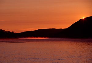 It was late afternoon and I realized that the 100 Km of hills and barrens that stretched westward towards the trans Canada and gulf of St. Lawrence wouldn't allow for much of a wind buffer. I had time for the short portage to the water and a diagonal route across the lake to the opposite corner where a sheltered channel led to the river delta. Winds had been brisk westerlies all afternoon but were starting to lighten has is usually the case late in the day. With gear packed tightly into a light 14' canoe I made haste to cross. Ten minutes out winds began to pick up once more and I quickened the pace using the extra push from the waves. The far side was still a good distance and waves were growing steadily breaking under the boat. It turned out to be a wild ride racing with foaming whitecaps that twisted the hull as they slid under and past. Finishing the crossing in record time my main concern now was staying off the shallow submerged boulders that line the rocky shore leading to the southwest arm of the lake. On rounding a point to enter the arm, sudden calm ensued has the sound of crashing water faded into the distance.
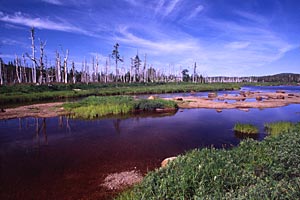
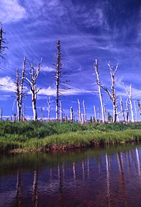
I could now focus on the surrounding landscape. White ghosts trees lined the shore, balsam fir ravaged by a past outbreak of bud worm or looper made imposing skeletons of dry hardened trunks and limbs. Although outbreaks are common it is unusual to see standing trees since they are normally harvested before dyeing for pulp or after for firewood. In this remote location the wasted timber has a natural and complimentary appearance. Starkly beautiful sculptures that show shape and form, contrasting against the live birches draped in leaves and the surrounding green barren hills. A few more kilometres and the rock lined shore gave way to wide swaths of sand as I entered the shallow Lloyds River delta. The waning light became mirrored in bands of color reflected amidst floating Lilly pads.
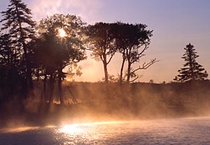
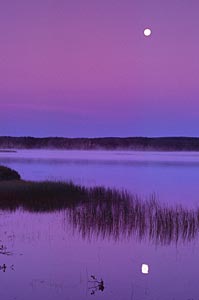
 At the height of summer, camping can be as uncomplicated as laying on a sandy beach. Daybreak however offers rare opportunities to shoot wildlife up close from a blind. So I popped out a self erecting tent and waited to be awakened by the predawn quacking and thrashing of ducks. It wasn't a long wait. In summer days can seem very long and monotonous has strong winds and harsh sunlight spoil both paddling and shooting opportunities There are brief periods in the day when the atmosphere becomes surreal and nature shows its most appealing side. Dawn is one of these times as animal activity becomes feverish following a night of rest. On this morning I am blessed with a setting crescent moon and light fog gradually lifting over still waters that echo a symphony of wildlife sounds. As the sun emerges from behind the crest of a silhouetted hill its first rays shoot out to illuminate and evaporate a layer of mist dancing across the water.
Paddling through the reserve is easy when the water is relatively high. At other times it is best to stay in the main stream channels as the sandy shallow open expanses are easy to strand on especially when high winds make paddling difficult. Judging from the season and current water levels its a safe bet that this isn't a problem other than in midsummer.
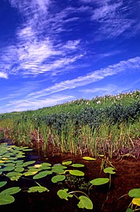
 Several hours of exploring leads to encounters with shorebirds, beavers, caribou, ducks and geese. The day is warm bright and windless, sun burning through old fog shrouded birches suggests the exotic appearance of a tropical rain forest. Yellow legs pecking near the shoreline are tame enough to approach without disturbing. There are several kilometres of waterway to explore before finally reach the end of the steadies where the river becomes rocky. All along, the channel course is hedged with meadowsweet, twisted larches provide unmistakable markers intermittently along the route. Beavers are especially abundant swimming back and forth between lodges built into the raised banks. Occasionally a caribou wanders through, sometimes taking an interest in aquatic plants that choke the tiny ponds connected to the main river course. Where the steadies end tall bone like snags tower over wide blades of blue flag iris contrasting death and renewal in an endless cycle. Boulders laying in the stream bed have the rusty brown appearance of iron bearing rock. These add to the intensity of colors in this natural garden of wild flowers, green grasses and blue water while streaming wisps of high cirrus cloud streak through a deep blue sky.
As the winds begin to blow briskly and the sun reaches its midday zenith, there is no option but to rest until it follows its arc towards the southwest and the light becomes more favourable for venturing upstream again. I notice that although geese can be heard they appear to be preferring the small ponds that scatter across the barren ridges to the open delta marshes. These ponds may offer better cover as nesting sites for the birds, especially where tuckamore protects them from predators.
 It is already past the middle of August and our short canoeing season is coming to a close. Winds become unreliable in late summer and fall and don't appear to be lessening much until near sunset. I decide to make the trip back down the lake as night closes in. Reaching the main body of the lake I'm looking forward to a fairly easy paddle up the leeward shore before crossing to the small sandy cove where the road ends. However finding a 20' patch of sandy beach hidden amongst several km of rocky shoreline in the dark would prove difficult, so I decide to chance crossing at the lower end making my way up the windward shore. Better to scout the entire length than making a wild stab from the other side. This turns out to be a less favorable option has the wind again picks up and I'm forced to go out into deeper water to avoid being thrown against the rocks. As was the case in crossing the day before, there's no backing out and eventually I'm able to reach the landing without incident. Its very difficult to find a strange place in the dark, not something you plan for but a worthwhile consideration.
As it turned out the next day on the way back the road a wild electric storm started to close in across the barrens. Driving north on the highway I was just skirting the edge evidenced by billowing nimbus clouds giving way to clear skies ahead. The area was too remote to pick up anything on my pocket vhf weather radio so I couldn't believe my luck. I'd dodged high winds and a incoming storm to enjoy a near perfect day for photography in a unique and special place that few people have ever seen. I turned on my truck radio to learn that the east coast of North America had just been crippled by a massive electrical blackout on the previous day making it a trip to remember and appreciate that much more.
